

Bus 21 in Liverpool links Queen Square Bus Station and Chadwell Road. The route is 18.0 km long with 55 stops, and the official schedule from Merseytravel puts the full trip at about 61 minutes. On a weekday it runs 58 trips in one direction, and 28 on a weekend day.
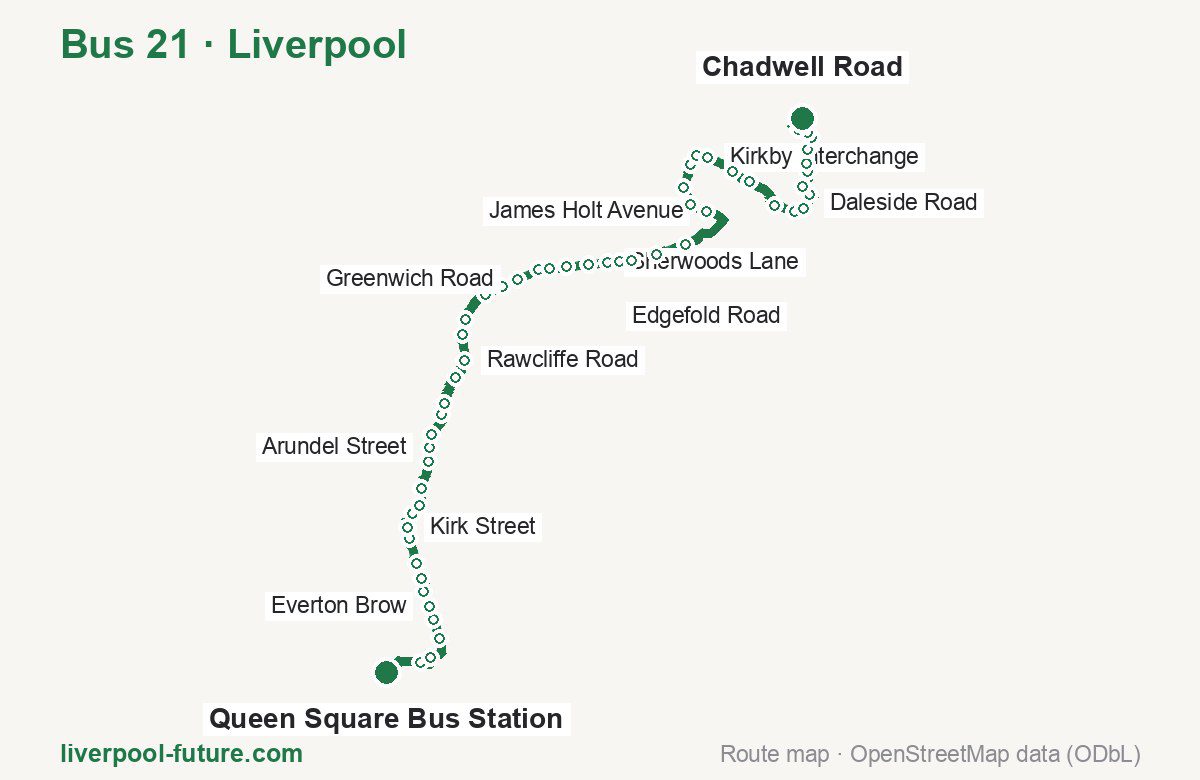
Route at a glance
| Mode | Bus |
|---|---|
| Route number | 21 |
| City | Liverpool |
| Operator | Merseytravel |
| Start → end | Queen Square Bus Station → Chadwell Road |
| End → start | Chadwell Road → Queen Square Bus Station |
| Route length | 18.0 km / 21.1 km in the opposite direction |
| Number of stops | 55 / 63 in the opposite direction |
| Travel time | about 61 minutes |
| Trips per day | 58 on weekdays, 28 on weekends one way (62 on weekdays → Queen Square Bus Station) |
| Frequency | peak 14–20 · midday 13–20 · weekend 27–65 |
| First / last trip from «Queen Square Bus Station» | 06:18 / 23:35 |
| First / last trip from «Chadwell Road» | 04:52 / 23:29 |
| Fare | 2.00 £ (fare in effect since September 2022) |
| Updated | August 22, 2026 |
Route of Bus 21
Outbound: Queen Square Bus Station → Chadwell Road
This direction has 55 stops and runs 18.0 km. The route passes Monument Place, Ludlow Street, Barlows Lane, Kirkby Interchange. Below is the full list with the distance from the first stop.
| No. | Stop | From start | Note |
|---|---|---|---|
| 1 | Queen Square Bus Station | 0.0 km | Terminus |
| 2 | Monument Place | 0.7 km | |
| 3 | Royal Liverpool University Hospital | 1.0 km | |
| 4 | College Street South | 1.5 km | |
| 5 | William Henry Street | 1.8 km | |
| 6 | Everton Brow | 2.0 km | |
| 7 | Roscommon Street | 2.3 km | |
| 8 | Rose Vale | 2.5 km | |
| 9 | Conway Street | 2.8 km | |
| 10 | Mitylene Street | 3.2 km | |
| 11 | Kirk Street | 3.4 km | |
| 12 | Sandheys Close | 3.7 km | |
| 13 | Fountains Road | 3.9 km | |
| 14 | Christopher Street | 4.2 km | |
| 15 | Ludlow Street | 4.6 km | |
| 16 | Arundel Street | 4.9 km | |
| 17 | Makin Street | 5.1 km | |
| 18 | Breeze Hill | 5.5 km | |
| 19 | York Street | 5.7 km | |
| 20 | Clock Tower Drive | 6.2 km | |
| 21 | Rawcliffe Road | 6.5 km | |
| 22 | Rice Lane Interchange | 7.0 km | |
| 23 | Orrell Park Interchange | 7.2 km | |
| 24 | Warbreck Moor | 7.8 km | |
| 25 | Goodacre Road | 8.1 km | |
| 26 | Greenwich Road | 8.4 km | |
| 27 | Seeds Lane | 8.8 km | |
| 28 | Barlows Lane | 9.0 km | |
| 29 | Fazakerley Interchange | 9.3 km | |
| 30 | Longmoor Close | 9.6 km | |
| 31 | Sherwoods Lane | 9.9 km | |
| 32 | New Hall Cottages | 10.1 km | |
| 33 | Haven Road | 10.4 km | |
| 34 | Aintree Lane | 10.8 km | |
| 35 | Ingoe Lane | 11.3 km | |
| 36 | James Holt Avenue | 12.4 km | |
| 37 | Ingoe Close | 12.7 km | |
| 38 | Houlston Road | 13.0 km | |
| 39 | Lingtree Road | 13.4 km | |
| 40 | Kirkby Interchange | 13.6 km | |
| 41 | Kirkby Interchange | 13.8 km | |
| 42 | Old Hall Lane | 14.3 km | |
| 43 | Kirkby Bus Station | 14.7 km | |
| 44 | Cherryfield Drive | 15.3 km | |
| 45 | Mainside Road | 15.7 km | |
| 46 | Edgefold Road | 15.9 km | |
| 47 | Westhead Walk | 16.2 km | |
| 48 | Hargate Road | 16.4 km | |
| 49 | Retford Road | 16.7 km | |
| 50 | Minstead Avenue | 16.9 km | |
| 51 | Daleside Road | 17.2 km | |
| 52 | Brook Hey Drive | 17.4 km | |
| 53 | Bigdale Drive | 17.5 km | |
| 54 | Wingate Road | 17.7 km | |
| 55 | Chadwell Road | 18.0 km | Terminus |
Inbound: Chadwell Road → Queen Square Bus Station
This direction has 63 stops and runs 21.1 km. The route passes Daleside Road, Simonswood Lane, Swainson Road, Pym Street. Below is the full list with the distance from the first stop.
| No. | Stop | From start | Note |
|---|---|---|---|
| 1 | Minstead Avenue | 0.0 km | Terminus |
| 2 | Daleside Road | 0.3 km | |
| 3 | Brook Hey Drive | 0.5 km | |
| 4 | Bigdale Drive | 0.7 km | |
| 5 | Wingate Road | 0.8 km | |
| 6 | Chadwell Road | 1.2 km | |
| 7 | Kenbury Road | 1.4 km | |
| 8 | Woodcote Close | 1.6 km | |
| 9 | Simonswood Lane | 1.8 km | |
| 10 | Brook Hey Drive | 2.0 km | |
| 11 | Birbeck Road | 2.2 km | |
| 12 | Quernmore Road | 2.6 km | |
| 13 | Sanderling Road | 2.8 km | |
| 14 | Bigdale Drive | 3.1 km | |
| 15 | Wyllin Road | 3.3 km | |
| 16 | Westhead Avenue | 3.5 km | |
| 17 | Simonswood Lane | 3.8 km | |
| 18 | Edgefold Road | 4.0 km | |
| 19 | Leeside Avenue | 4.3 km | |
| 20 | Wellfield Avenue | 4.7 km | |
| 21 | Kirkby Bus Station | 5.2 km | |
| 22 | James Holt Avenue | 5.7 km | |
| 23 | Kirkby Interchange | 6.2 km | |
| 24 | Alvanley Road | 6.6 km | |
| 25 | Mercer Avenue | 7.0 km | |
| 26 | Fernhurst Road | 7.4 km | |
| 27 | James Holt Avenue | 7.7 km | |
| 28 | Burtons Way | 8.7 km | |
| 29 | Field Lane | 9.2 km | |
| 30 | Edgemoor Drive | 9.7 km | |
| 31 | Formosa Drive | 10.0 km | |
| 32 | Swainson Road | 10.2 km | |
| 33 | Longmoor Close | 10.4 km | |
| 34 | Fazakerley Interchange | 10.8 km | |
| 35 | Seventh Avenue | 11.1 km | |
| 36 | Higher Lane | 11.4 km | |
| 37 | Bradville Road | 11.7 km | |
| 38 | Goodacre Road | 12.0 km | |
| 39 | Solar Road | 12.2 km | |
| 40 | Grace Road | 12.5 km | |
| 41 | Orrell Park Interchange | 12.6 km | |
| 42 | Rice Lane Interchange | 13.1 km | |
| 43 | Fazakerley Road | 13.5 km | |
| 44 | Cavendish Drive | 13.9 km | |
| 45 | Denbigh Road | 14.3 km | |
| 46 | Church Lane | 14.6 km | |
| 47 | Pym Street | 14.9 km | |
| 48 | Wilburn Street | 15.2 km | |
| 49 | Oxton Street | 15.5 km | |
| 50 | Christopher Street | 15.9 km | |
| 51 | Woodhouse Close | 16.1 km | |
| 52 | Sandheys Close | 16.4 km | |
| 53 | Patmos Close | 16.8 km | |
| 54 | John Bagot Close | 17.2 km | |
| 55 | Rose Vale | 17.5 km | |
| 56 | Roscommon Street | 17.8 km | |
| 57 | Everton Brow | 18.0 km | |
| 58 | William Henry Street | 18.3 km | |
| 59 | College Street South | 18.6 km | |
| 60 | Erskine Street | 18.7 km | |
| 61 | Greek Street | 19.3 km | |
| 62 | Queen Square Bus Station | 20.1 km | |
| 63 | Castle Street | 21.1 km | Terminus |
Schedule and frequency
According to the official schedule from Merseytravel, the route runs 58 trips in one direction on a weekday, and 28 on a weekend day.
| Direction | Weekdays | Weekends and holidays |
|---|---|---|
| From «Queen Square Bus Station» | 06:18 — 23:35 | 07:03 — 23:05 |
| From «Chadwell Road» | 04:52 — 23:29 | 05:57 — 22:00 |
Frequency calculated from the departure table: in the morning peak buses run every 14–20 minutes, most often every 15; midday every 13–20 minutes; in the afternoon peak every 15–20; on weekends every 27–65 minutes.
Fare and payment
A single ride costs 2.00 £ — fare in effect since September 2022. The same fare applies to buses in Merseyside.
No adult single bus journey costs more than £2.00 — this cap set by the Liverpool City Region applies to every operator in Merseyside and Halton. Each boarding counts as a separate journey: there is no transfer. A Solo day ticket is £5.90.
Frequently asked questions
How much does a ride on bus 21 cost?
2.00 £ for a single ride — fare in effect since September 2022.
When do the first and last trips run?
From Queen Square Bus Station the first is at 06:18 and the last at 23:35. From Chadwell Road they are 04:52 and 23:29.
How long does the trip from Queen Square Bus Station to Chadwell Road take?
About 61 minutes end to end — the median of full trips in the official schedule.
How many stops does the route have?
55 outbound and 63 inbound according to the official GTFS feed. The two lists do not match exactly.
Does bus 21 run on weekends?
Yes. On weekends and holidays there are 28 trips in one direction, running from Queen Square Bus Station between 07:03 and 23:05.
Every route number with its termini, operating hours and travel time is collected in the Liverpool buses overview.
Data current as of August 22, 2026. Schedule and termini — Merseytravel. Fares — Merseytravel. Stop list, schedule and route geometry come from the official GTFS feed (Bus Open Data Service (BODS)).