

Bus 61A in Liverpool links Bootle Bus Station and Ashfield Road. The route is 0.0 km long with 57 stops, and the official schedule from Merseytravel puts the full trip at about 83 minutes. On a weekday it runs 17 trips in one direction.
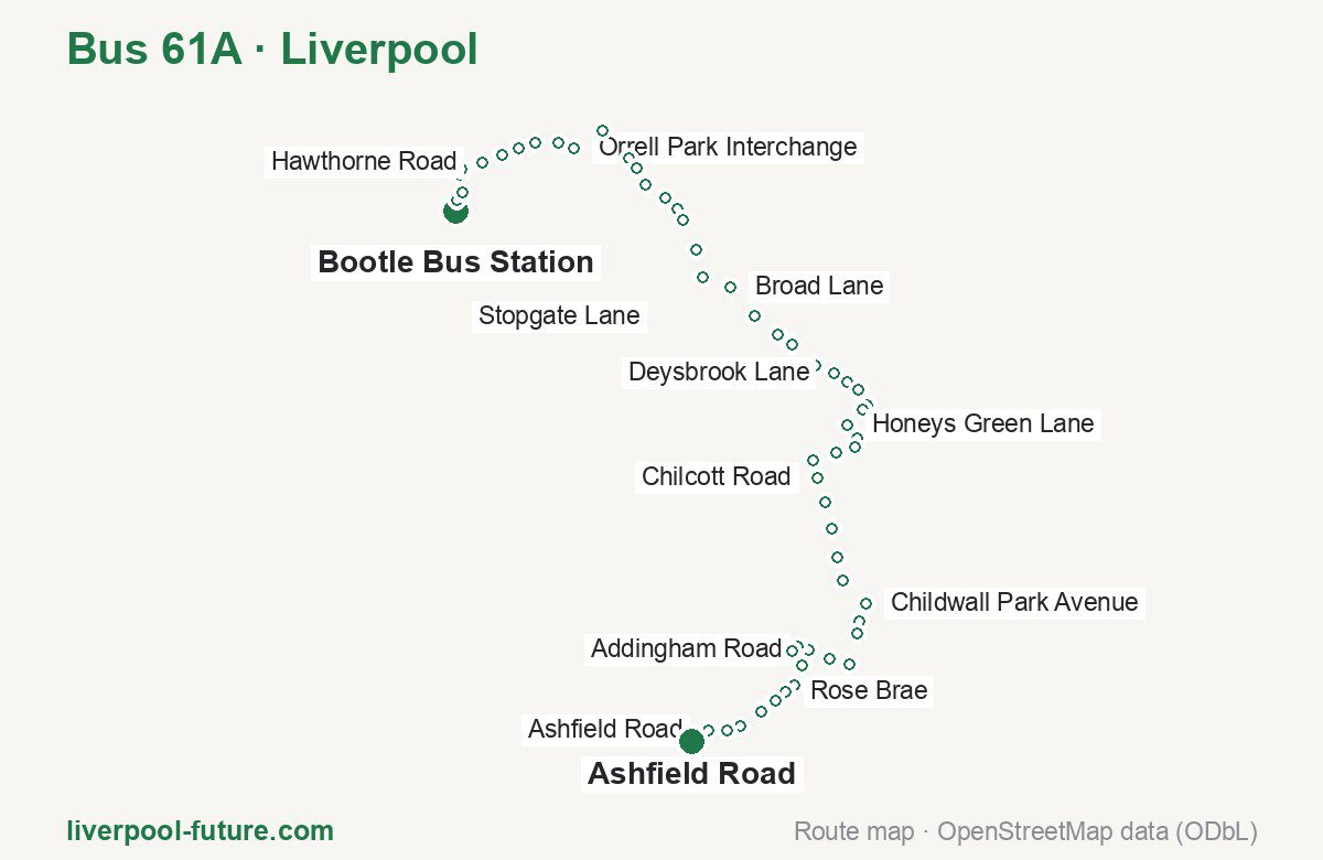
Route at a glance
| Mode | Bus |
|---|---|
| Route number | 61A |
| City | Liverpool |
| Operator | Merseytravel |
| Start → end | Bootle Bus Station → Ashfield Road |
| End → start | Ashfield Road → Bootle Bus Station |
| Route length | 0.0 km / 0.0 km in the opposite direction |
| Number of stops | 57 / 54 in the opposite direction |
| Travel time | about 83 minutes |
| Trips per day | 17 on weekdays one way |
| Frequency | peak 23–25 · midday 20–24 |
| First / last trip from «Bootle Bus Station» | 06:24 / 17:26 |
| First / last trip from «Ashfield Road» | 06:25 / 17:33 |
| Fare | 2.00 £ (fare in effect since September 2022) |
| Updated | August 22, 2026 |
Route of Bus 61A
Outbound: Bootle Bus Station → Ashfield Road
This direction has 57 stops. The route passes Hornby Road, Hanson Road, Kendal Park, Childwall Park Avenue. The full list of stops in order is below.
| No. | Stop | From start | Note |
|---|---|---|---|
| 1 | Bootle Bus Station | 0.0 km | Terminus |
| 2 | Hornby Road | 0.0 km | |
| 3 | Hornby Road | 0.0 km | |
| 4 | Knowsley Road | 0.0 km | |
| 5 | Knowsley Road | 0.0 km | |
| 6 | Hawthorne Road | 0.0 km | |
| 7 | Fernhill Road | 0.0 km | |
| 8 | Ballantyne Grove | 0.0 km | |
| 9 | Moss Lane | 0.0 km | |
| 10 | Burwen Drive | 0.0 km | |
| 11 | Orrell Park Interchange | 0.0 km | |
| 12 | Warbreck Moor | 0.0 km | |
| 13 | Hartley Avenue | 0.0 km | |
| 14 | Brookfield Drive | 0.0 km | |
| 15 | Hanson Road | 0.0 km | |
| 16 | Stopgate Lane | 0.0 km | |
| 17 | Long Lane | 0.0 km | |
| 18 | Tilston Road | 0.0 km | |
| 19 | Fairfax Road | 0.0 km | |
| 20 | Utting Avenue East | 0.0 km | |
| 21 | Broad Lane | 0.0 km | |
| 22 | Muirhead Avenue East | 0.0 km | |
| 23 | Almonds Grove | 0.0 km | |
| 24 | Meadow Lane | 0.0 km | |
| 25 | Marlfield Road | 0.0 km | |
| 26 | Deysbrook Lane | 0.0 km | |
| 27 | Thornhead Lane | 0.0 km | |
| 28 | Kendal Park | 0.0 km | |
| 29 | Martlett Road | 0.0 km | |
| 30 | Honey’s Green Close | 0.0 km | |
| 31 | Honeys Green Lane | 0.0 km | |
| 32 | Meadowcroft Park | 0.0 km | |
| 33 | Thomas Lane | 0.0 km | |
| 34 | Rudyard Road | 0.0 km | |
| 35 | Queens Drive | 0.0 km | |
| 36 | Chilcott Road | 0.0 km | |
| 37 | Broadgreen Hospital | 0.0 km | |
| 38 | Bowring Park Road | 0.0 km | |
| 39 | Rocky Lane | 0.0 km | |
| 40 | Childwall Valley Road | 0.0 km | |
| 41 | Childwall Park Avenue | 0.0 km | |
| 42 | Irene Road | 0.0 km | |
| 43 | Woolton Road | 0.0 km | |
| 44 | Menlove Avenue | 0.0 km | |
| 45 | Calder Drive | 0.0 km | |
| 46 | Addingham Road | 0.0 km | |
| 47 | Wyndcote Road | 0.0 km | |
| 48 | Ensworth Road | 0.0 km | |
| 49 | Wembley Road | 0.0 km | |
| 50 | Mather Avenue | 0.0 km | |
| 51 | Rose Brae | 0.0 km | |
| 52 | Mossley Hill Interchange | 0.0 km | |
| 53 | Mossley Hill Interchange | 0.0 km | |
| 54 | Mossley Hill Road | 0.0 km | |
| 55 | Rosemont Road | 0.0 km | |
| 56 | Ashfield Road | 0.0 km | |
| 57 | Ashfield Road | 0.0 km | Terminus |
Inbound: Ashfield Road → Bootle Bus Station
This direction has 54 stops. The route passes Elmswood Road, Irene Road, Martlett Road, Mater Close. The full list of stops in order is below.
| No. | Stop | From start | Note |
|---|---|---|---|
| 1 | Ashfield Road | 0.0 km | Terminus |
| 2 | Elmswood Road | 0.0 km | |
| 3 | Gladeville Road | 0.0 km | |
| 4 | North Mossley Hill Road | 0.0 km | |
| 5 | Mossley Hill Interchange | 0.0 km | |
| 6 | Ribbledale Road | 0.0 km | |
| 7 | Reedale Road | 0.0 km | |
| 8 | Rose Lane | 0.0 km | |
| 9 | Garthdale Road | 0.0 km | |
| 10 | Queens Drive | 0.0 km | |
| 11 | Addingham Road | 0.0 km | |
| 12 | Green Lane | 0.0 km | |
| 13 | Cromptons Lane | 0.0 km | |
| 14 | Woolton Road | 0.0 km | |
| 15 | Irene Road | 0.0 km | |
| 16 | Dunbabin Road | 0.0 km | |
| 17 | Corbridge Road | 0.0 km | |
| 18 | Charnley Drive | 0.0 km | |
| 19 | Thingwall Road | 0.0 km | |
| 20 | Waldgrave Road | 0.0 km | |
| 21 | Broadgreen Hospital | 0.0 km | |
| 22 | Oakhill Road | 0.0 km | |
| 23 | Chatterton Road | 0.0 km | |
| 24 | Alder Hey Hospital | 0.0 km | |
| 25 | East Prescot Road | 0.0 km | |
| 26 | Honeys Green Lane | 0.0 km | |
| 27 | Blackmoor Drive | 0.0 km | |
| 28 | Martlett Road | 0.0 km | |
| 29 | Alvanley Road | 0.0 km | |
| 30 | Sandfield Park East | 0.0 km | |
| 31 | Norris Green Road | 0.0 km | |
| 32 | Mill Lane | 0.0 km | |
| 33 | Haymans Green | 0.0 km | |
| 34 | Circular Road East | 0.0 km | |
| 35 | Broad Lane | 0.0 km | |
| 36 | Lorenzo Drive | 0.0 km | |
| 37 | Broadway | 0.0 km | |
| 38 | Townsend Avenue | 0.0 km | |
| 39 | Parthenon Drive | 0.0 km | |
| 40 | Ardville Road | 0.0 km | |
| 41 | Mater Close | 0.0 km | |
| 42 | LIver Industrial Estate | 0.0 km | |
| 43 | Hanson Road | 0.0 km | |
| 44 | Brookfield Drive | 0.0 km | |
| 45 | Hartley Avenue | 0.0 km | |
| 46 | Solar Road | 0.0 km | |
| 47 | Orrell Park Interchange | 0.0 km | |
| 48 | Orrell Park Interchange | 0.0 km | |
| 49 | Hanford Avenue | 0.0 km | |
| 50 | Whinfield Road | 0.0 km | |
| 51 | Marsh Avenue | 0.0 km | |
| 52 | Fernhill Road | 0.0 km | |
| 53 | Sefton Road | 0.0 km | |
| 54 | Bootle Bus Station | 0.0 km | Terminus |
Schedule and frequency
According to the official schedule from Merseytravel, the route runs 17 trips in one direction on a weekday.
| Direction | Weekdays | Weekends and holidays |
|---|---|---|
| From «Bootle Bus Station» | 06:24 — 17:26 | — — — |
| From «Ashfield Road» | 06:25 — 17:33 | — — — |
Frequency calculated from the departure table: in the morning peak buses run every 23–25 minutes, most often every 24; midday every 20–24 minutes; in the afternoon peak every 20.
Fare and payment
A single ride costs 2.00 £ — fare in effect since September 2022. The same fare applies to buses in Merseyside.
No adult single bus journey costs more than £2.00 — this cap set by the Liverpool City Region applies to every operator in Merseyside and Halton. Each boarding counts as a separate journey: there is no transfer. A Solo day ticket is £5.90.
Frequently asked questions
How much does a ride on bus 61A cost?
2.00 £ for a single ride — fare in effect since September 2022.
When do the first and last trips run?
From Bootle Bus Station the first is at 06:24 and the last at 17:26. From Ashfield Road they are 06:25 and 17:33.
How long does the trip from Bootle Bus Station to Ashfield Road take?
About 83 minutes end to end — the median of full trips in the official schedule.
How many stops does the route have?
57 outbound and 54 inbound according to the official GTFS feed. The two lists do not match exactly.
Does bus 61A run on weekends?
Yes, the route runs every day, with a separate weekend schedule.
Every route number with its termini, operating hours and travel time is collected in the Liverpool buses overview.
Data current as of August 22, 2026. Schedule and termini — Merseytravel. Fares — Merseytravel. Stop list, schedule and route geometry come from the official GTFS feed (Bus Open Data Service (BODS)).