

Bus 215 in Liverpool links Aintree University Hospital and Lavender Way. The route is 21.6 km long with 56 stops, and the official schedule from Merseytravel puts the full trip at about 52 minutes. On a weekday it runs 11 trips in one direction.
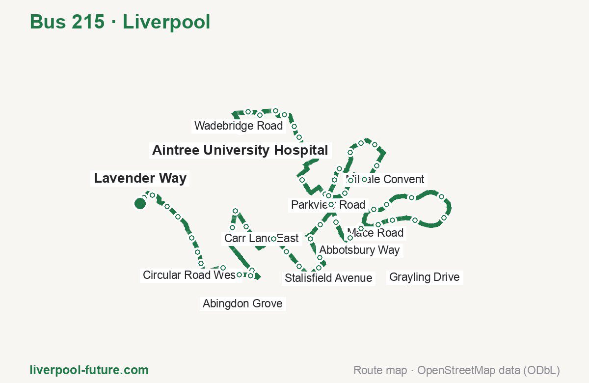
Route at a glance
| Mode | Bus |
|---|---|
| Route number | 215 |
| City | Liverpool |
| Operator | Merseytravel |
| Start → end | Aintree University Hospital → Lavender Way |
| End → start | Lavender Way → Aintree University Hospital |
| Route length | 21.6 km / 21.5 km in the opposite direction |
| Number of stops | 56 / 60 in the opposite direction |
| Travel time | about 52 minutes |
| Trips per day | 11 on weekdays one way |
| Frequency | peak 60 · midday 60 |
| First / last trip from «Aintree University Hospital» | 07:58 / 17:58 |
| First / last trip from «Lavender Way» | 07:21 / 17:00 |
| Fare | 2.00 £ (fare in effect since September 2022) |
| Updated | August 22, 2026 |
Route of Bus 215
Outbound: Aintree University Hospital → Lavender Way
This direction has 56 stops and runs 21.6 km. The route passes Karonga Way, Parkview Road, Midhurst Road, Stalisfield Avenue. Below is the full list with the distance from the first stop.
| No. | Stop | From start | Note |
|---|---|---|---|
| 1 | Aintree University Hospital | 0.0 km | Terminus |
| 2 | Karonga Way | 0.6 km | |
| 3 | Formosa Drive | 0.8 km | |
| 4 | Drake Close | 1.1 km | |
| 5 | Gribble Road | 1.4 km | |
| 6 | Wadebridge Road | 1.7 km | |
| 7 | Stonebridge Lane | 1.9 km | |
| 8 | Invergarry Road | 3.1 km | |
| 9 | Mansion Drive | 3.7 km | |
| 10 | Parkstile Lane | 3.9 km | |
| 11 | Milvale Convent | 4.2 km | |
| 12 | Croxteth Comp School | 4.4 km | |
| 13 | Totnes Road | 4.9 km | |
| 14 | Parkview Road | 5.2 km | |
| 15 | Parkview Road | 5.5 km | |
| 16 | Parkview Road | 6.0 km | |
| 17 | Trispen Road | 6.3 km | |
| 18 | Cubert Road | 6.7 km | |
| 19 | Sceptre Road | 6.9 km | |
| 20 | Garter Close | 7.4 km | |
| 21 | Mace Road | 7.7 km | |
| 22 | Croxteth Hall Lane | 8.1 km | |
| 23 | Abbeyfield Drive | 8.4 km | |
| 24 | Pinewood Avenue | 8.8 km | |
| 25 | Veronica Close | 9.1 km | |
| 26 | Abbotsbury Way | 9.6 km | |
| 27 | Zander Grove | 10.2 km | |
| 28 | Midhurst Road | 10.7 km | |
| 29 | Langley Close | 11.2 km | |
| 30 | Crompton Drive | 11.7 km | |
| 31 | Grayling Drive | 11.9 km | |
| 32 | Fir Tree Drive South | 12.3 km | |
| 33 | Croxteth Hall Lane | 12.6 km | |
| 34 | Mace Road | 7.7 km | |
| 35 | Carr Lane East | 13.6 km | |
| 36 | Carr Lane East | 13.9 km | |
| 37 | Etal Close | 14.3 km | |
| 38 | Kerman Close | 14.6 km | |
| 39 | Clanfield Road | 15.1 km | |
| 40 | Branthwaite Crescent | 15.4 km | |
| 41 | Stalisfield Avenue | 15.8 km | |
| 42 | Sedgemoor Road | 16.6 km | |
| 43 | Sedgemoor Road | 17.0 km | |
| 44 | Norwyn Road | 17.3 km | |
| 45 | Broad Lane | 18.2 km | |
| 46 | Circular Road West | 18.5 km | |
| 47 | Morningside Road | 18.7 km | |
| 48 | Townsend Avenue | 19.1 km | |
| 49 | Knighton Road | 19.6 km | |
| 50 | Peploe Road | 19.9 km | |
| 51 | Abingdon Grove | 20.1 km | |
| 52 | Forsythia Close | 20.6 km | |
| 53 | Chestnut Road | 20.9 km | |
| 54 | Freesia Avenue | 21.2 km | |
| 55 | Buttercup Way | 21.4 km | |
| 56 | Lavender Way | 21.6 km | Terminus |
Inbound: Lavender Way → Aintree University Hospital
This direction has 60 stops and runs 21.5 km. The route passes Buttercup Way, Sedgemoor Road, Verwood Drive, Parkview Road. Below is the full list with the distance from the first stop.
| No. | Stop | From start | Note |
|---|---|---|---|
| 1 | Honeysuckle Drive | 0.0 km | Terminus |
| 2 | Buttercup Way | 0.2 km | |
| 3 | Freesia Avenue | 0.4 km | |
| 4 | Chestnut Road | 0.7 km | |
| 5 | Forsythia Close | 1.0 km | |
| 6 | Walton Hall Avenue | 1.4 km | |
| 7 | Peploe Road | 1.7 km | |
| 8 | Lambourne Road | 2.0 km | |
| 9 | Daneville Road | 2.5 km | |
| 10 | Broad Lane | 2.8 km | |
| 11 | Lorenzo Drive | 3.1 km | |
| 12 | Broad Lane | 3.3 km | |
| 13 | Parthenon Drive | 4.0 km | |
| 14 | Gable View | 4.2 km | |
| 15 | Sedgemoor Road | 5.0 km | |
| 16 | Sedgemoor Road | 5.4 km | |
| 17 | Utting Avenue East | 5.8 km | |
| 18 | Gayhurst Crescent | 6.1 km | |
| 19 | Clanfield Road | 6.4 km | |
| 20 | Wingrave Way | 6.9 km | |
| 21 | Etal Close | 7.2 km | |
| 22 | Carr Lane East | 7.9 km | |
| 23 | Mace Road | 8.4 km | |
| 24 | Croxteth Hall Lane | 8.9 km | |
| 25 | Abbeyfield Drive | 9.2 km | |
| 26 | Grayling Drive | 9.6 km | |
| 27 | Milford Drive | 9.8 km | |
| 28 | Langley Close | 10.2 km | |
| 29 | Mullwood Close | 10.5 km | |
| 30 | Verwood Drive | 11.1 km | |
| 31 | Nightingale Road | 11.4 km | |
| 32 | Woodvale Road | 11.7 km | |
| 33 | Measham Way | 12.0 km | |
| 34 | Veronica Close | 12.3 km | |
| 35 | Crucian Way | 12.6 km | |
| 36 | Fir Tree Drive South | 13.1 km | |
| 37 | Croxteth Hall Lane | 13.3 km | |
| 38 | Mace Road | 8.4 km | |
| 39 | Standard Road | 14.3 km | |
| 40 | Unicorn Road | 14.6 km | |
| 41 | Cubert Road | 14.8 km | |
| 42 | Trispen Road | 15.2 km | |
| 43 | Parkview Road | 15.5 km | |
| 44 | Parkview Road | 16.0 km | |
| 45 | Petherick Road | 16.3 km | |
| 46 | Falmouth Road | 16.6 km | |
| 47 | Croxteth Comp School | 17.1 km | |
| 48 | Standard Road | 17.4 km | |
| 49 | Mansion Drive | 17.8 km | |
| 50 | Invergarry Road | 18.3 km | |
| 51 | Stonedale Cresent | 18.7 km | |
| 52 | Stonebridge Lane | 18.9 km | |
| 53 | Stonebridge Lane | 19.5 km | |
| 54 | Field Lane | 19.8 km | |
| 55 | Gribble Road | 20.1 km | |
| 56 | Drake Crescent | 20.4 km | |
| 57 | Formosa Drive | 20.6 km | |
| 58 | Manica Crescent | 20.9 km | |
| 59 | Aintree University Hospital | 21.3 km | |
| 60 | Aintree University Hospital | 21.5 km | Terminus |
Schedule and frequency
According to the official schedule from Merseytravel, the route runs 11 trips in one direction on a weekday.
| Direction | Weekdays | Weekends and holidays |
|---|---|---|
| From «Aintree University Hospital» | 07:58 — 17:58 | — — — |
| From «Lavender Way» | 07:21 — 17:00 | — — — |
Frequency calculated from the departure table: in the morning peak buses run every 60 minutes; midday every 60 minutes.
Fare and payment
A single ride costs 2.00 £ — fare in effect since September 2022. The same fare applies to buses in Merseyside.
No adult single bus journey costs more than £2.00 — this cap set by the Liverpool City Region applies to every operator in Merseyside and Halton. Each boarding counts as a separate journey: there is no transfer. A Solo day ticket is £5.90.
Frequently asked questions
How much does a ride on bus 215 cost?
2.00 £ for a single ride — fare in effect since September 2022.
When do the first and last trips run?
From Aintree University Hospital the first is at 07:58 and the last at 17:58. From Lavender Way they are 07:21 and 17:00.
How long does the trip from Aintree University Hospital to Lavender Way take?
About 52 minutes end to end — the median of full trips in the official schedule.
How many stops does the route have?
56 outbound and 60 inbound according to the official GTFS feed. The two lists do not match exactly.
Does bus 215 run on weekends?
Yes, the route runs every day, with a separate weekend schedule.
Every route number with its termini, operating hours and travel time is collected in the Liverpool buses overview.
Data current as of August 22, 2026. Schedule and termini — Merseytravel. Fares — Merseytravel. Stop list, schedule and route geometry come from the official GTFS feed (Bus Open Data Service (BODS)).