

Bus 1 in Liverpool links Railway Station and Queen Square. The route is 39.0 km long with 79 stops, and the official schedule from Merseytravel puts the full trip at about 111 minutes. On a weekday it runs 38 trips in one direction, and 28 on a weekend day.
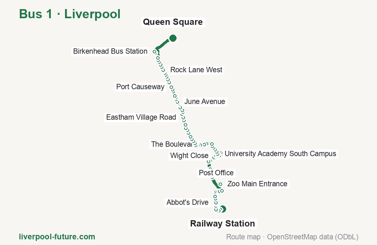
Route at a glance
| Mode | Bus |
|---|---|
| Route number | 1 |
| City | Liverpool |
| Operator | Merseytravel |
| Start → end | Railway Station → Queen Square |
| End → start | Queen Square → Railway Station |
| Route length | 39.0 km / 39.8 km in the opposite direction |
| Number of stops | 79 / 77 in the opposite direction |
| Travel time | about 111 minutes |
| Trips per day | 38 on weekdays, 28 on weekends one way |
| Frequency | peak 20–40 · midday 20–40 · weekend 20–50 |
| First / last trip from «Railway Station» | 05:30 / 23:30 |
| First / last trip from «Queen Square» | 04:56 / 23:50 |
| Fare | 2.00 £ (fare in effect since September 2022) |
| Updated | August 22, 2026 |
Route of Bus 1
Outbound: Railway Station → Queen Square
This direction has 79 stops and runs 39.0 km. The route passes Hoole Way, Ramsey Road, Bulls Head, Mark Rake. Below is the full list with the distance from the first stop.
| No. | Stop | From start | Note |
|---|---|---|---|
| 1 | Railway Station | 0.0 km | Terminus |
| 2 | Hoole Way | 0.4 km | |
| 3 | Chester Bus Interchange | 0.9 km | |
| 4 | Bull & Stirrup | 1.3 km | |
| 5 | Northgate Church | 1.6 km | |
| 6 | Dawson Drive | 2.1 km | |
| 7 | Waterloo Road | 2.4 km | |
| 8 | Abbot’s Drive | 2.6 km | |
| 9 | Countess Hospital | 3.1 km | |
| 10 | Beechway | 3.5 km | |
| 11 | Kingsmead | 4.2 km | |
| 12 | Demage Lane | 4.5 km | |
| 13 | Lawn Drive | 4.7 km | |
| 14 | The Wheatsheaf | 5.0 km | |
| 15 | Zoo Main Entrance | 6.6 km | |
| 16 | Station Road | 8.9 km | |
| 17 | Church Lane | 9.2 km | |
| 18 | Gordon Lane | 10.1 km | |
| 19 | Strawberry Roundabout | 11.2 km | |
| 20 | Lundy Drive | 12.2 km | |
| 21 | Ramsey Road | 12.4 km | |
| 22 | Wight Close | 12.8 km | |
| 23 | Longlooms Road | 13.0 km | |
| 24 | Longlooms Road | 13.2 km | |
| 25 | Coliseum & Cinema | 13.5 km | |
| 26 | Outlet Village | 14.2 km | |
| 27 | Blue Planet Aquarium | 14.9 km | |
| 28 | David Lloyd Leisure Centre | 15.2 km | |
| 29 | University Academy South Campus | 15.3 km | |
| 30 | Birkett Avenue | 15.6 km | |
| 31 | Underwood Drive | 16.0 km | |
| 32 | Grace Arms | 16.4 km | |
| 33 | Whitby Park | 16.6 km | |
| 34 | Ellesmere Port Bus Interchange | 17.0 km | |
| 35 | Tennyson Road | 17.9 km | |
| 36 | The Boulevard | 18.2 km | |
| 37 | Sutton Way Hotel | 18.8 km | |
| 38 | Bebington Road | 19.2 km | |
| 39 | Heswall Road | 19.4 km | |
| 40 | Bulls Head | 19.6 km | |
| 41 | Whetstone Hey | 19.9 km | |
| 42 | Wetherby Way | 20.3 km | |
| 43 | Post Office | 20.6 km | |
| 44 | Red Lion PH | 21.0 km | |
| 45 | Burleydam Garden Centre | 21.6 km | |
| 46 | Half Way House | 22.1 km | |
| 47 | St Mary’s Church | 22.4 km | |
| 48 | Crossroads | 22.9 km | |
| 49 | M53 | 23.6 km | |
| 50 | Eastham Village Road | 24.0 km | |
| 51 | Bridle Road | 24.5 km | |
| 52 | Carlett Boulevard | 24.8 km | |
| 53 | Heygarth Road | 25.0 km | |
| 54 | Plymyard Cemetery | 25.5 km | |
| 55 | Allport Road | 26.0 km | |
| 56 | Mendell Close | 26.2 km | |
| 57 | June Avenue | 26.4 km | |
| 58 | Bromborough Village | 26.8 km | |
| 59 | Mark Rake | 27.1 km | |
| 60 | Croft Avenue | 27.3 km | |
| 61 | New Chester Road | 27.4 km | |
| 62 | Mill Road | 28.1 km | |
| 63 | Hesketh Way | 28.4 km | |
| 64 | Port Causeway | 28.8 km | |
| 65 | Shore Drive | 29.5 km | |
| 66 | Willowbank Road | 29.9 km | |
| 67 | Legh Road | 30.4 km | |
| 68 | New Ferry Park | 30.6 km | |
| 69 | Hassal Road | 31.0 km | |
| 70 | Knowsley Road | 31.2 km | |
| 71 | Rock Lane West | 31.4 km | |
| 72 | Bedford Road | 31.9 km | |
| 73 | Woburn Place | 32.2 km | |
| 74 | Union Street | 32.6 km | |
| 75 | Turbine Road | 33.0 km | |
| 76 | Valiant Way | 33.2 km | |
| 77 | Grange Road | 34.4 km | |
| 78 | Birkenhead Bus Station | 34.8 km | |
| 79 | Queen Square | 39.0 km | Terminus |
Inbound: Queen Square → Railway Station
This direction has 77 stops and runs 39.8 km. The route passes Hinson Street, Spital Road, Wetherby Way, Wight Close. Below is the full list with the distance from the first stop.
| No. | Stop | From start | Note |
|---|---|---|---|
| 1 | Whitechapel | 0.0 km | Terminus |
| 2 | Hinson Street | 4.3 km | |
| 3 | Birkenhead Bus Station | 5.0 km | |
| 4 | Grange Road East | 5.4 km | |
| 5 | Campbeltown Road | 6.1 km | |
| 6 | Turbine Road | 6.6 km | |
| 7 | St Pauls Road | 7.5 km | |
| 8 | Bedford Place | 7.7 km | |
| 9 | The Hawthornes | 8.2 km | |
| 10 | Knowsley Road | 8.4 km | |
| 11 | Platt Grove | 8.6 km | |
| 12 | Hassal Road | 8.8 km | |
| 13 | Earl Street | 9.2 km | |
| 14 | Beaconsfield Road | 9.6 km | |
| 15 | Portbury Close | 9.9 km | |
| 16 | Shore Drive | 10.3 km | |
| 17 | Pool Lane | 11.0 km | |
| 18 | Port Causeway | 11.3 km | |
| 19 | Magazine Road | 11.7 km | |
| 20 | Spital Road | 12.4 km | |
| 21 | Croft Avenue East | 12.6 km | |
| 22 | Stanhope Drive | 12.7 km | |
| 23 | Bromborough Village | 13.1 km | |
| 24 | New Chester Road | 13.4 km | |
| 25 | Woodyear Road | 14.0 km | |
| 26 | Plymyard Cemetery | 14.3 km | |
| 27 | Park Road | 14.7 km | |
| 28 | Carlett Boulevard | 15.1 km | |
| 29 | Stanley Lane | 15.3 km | |
| 30 | Eastham Village Road | 15.8 km | |
| 31 | M53 | 16.2 km | |
| 32 | Crossroads | 17.1 km | |
| 33 | St Mary’s Church | 17.4 km | |
| 34 | School Lane | 17.9 km | |
| 35 | St Paul’s Church | 18.2 km | |
| 36 | Red Lion PH | 18.7 km | |
| 37 | Post Office | 19.1 km | |
| 38 | Wetherby Way | 19.4 km | |
| 39 | Whetstone Hey | 19.9 km | |
| 40 | Bulls Head | 20.2 km | |
| 41 | Heswall Road | 20.4 km | |
| 42 | Bebington Road | 20.7 km | |
| 43 | Sutton Way Hotel | 21.1 km | |
| 44 | The Boulevard | 21.5 km | |
| 45 | Tennyson Road | 21.9 km | |
| 46 | Ellesmere Port Bus Interchange | 22.8 km | |
| 47 | Whitby Park | 23.2 km | |
| 48 | Grace Arms | 23.5 km | |
| 49 | Underwood Drive | 23.9 km | |
| 50 | Stanney Lane | 24.3 km | |
| 51 | David Lloyd Leisure Centre | 24.6 km | |
| 52 | Coliseum & Cinema | 24.9 km | |
| 53 | Outlet Village | 25.6 km | |
| 54 | Blue Planet Aquarium | 26.3 km | |
| 55 | Longlooms Road | 26.8 km | |
| 56 | Wight Close | 27.0 km | |
| 57 | Ramsey Road | 27.4 km | |
| 58 | Lundy Drive | 27.6 km | |
| 59 | Strawberry Roundabout | 28.6 km | |
| 60 | Gordon Lane | 29.6 km | |
| 61 | Church Lane | 30.6 km | |
| 62 | Rake Lane | 31.0 km | |
| 63 | Zoo Main Entrance | 33.1 km | |
| 64 | Heath Road | 34.7 km | |
| 65 | Lawn Drive | 34.9 km | |
| 66 | Demage Lane | 35.1 km | |
| 67 | The Frog | 35.6 km | |
| 68 | Beechway | 36.1 km | |
| 69 | Countess Hospital | 36.5 km | |
| 70 | The Mill PH | 36.6 km | |
| 71 | Abbot’s Drive | 37.0 km | |
| 72 | Waterloo Road | 37.2 km | |
| 73 | Abbot’s Grange | 37.6 km | |
| 74 | Tudor Place | 38.0 km | |
| 75 | Delamere Street | 38.2 km | |
| 76 | Chester Bus Interchange | 38.5 km | |
| 77 | Railway Station | 39.8 km | Terminus |
Schedule and frequency
According to the official schedule from Merseytravel, the route runs 38 trips in one direction on a weekday, and 28 on a weekend day.
| Direction | Weekdays | Weekends and holidays |
|---|---|---|
| From «Railway Station» | 05:30 — 23:30 | 07:47 — 23:30 |
| From «Queen Square» | 04:56 — 23:50 | 06:52 — 23:50 |
Frequency calculated from the departure table: in the morning peak buses run every 20–40 minutes, most often every 30; midday every 20–40 minutes; in the afternoon peak every 25–30; on weekends every 20–50 minutes.
Fare and payment
A single ride costs 2.00 £ — fare in effect since September 2022. The same fare applies to buses in Merseyside.
No adult single bus journey costs more than £2.00 — this cap set by the Liverpool City Region applies to every operator in Merseyside and Halton. Each boarding counts as a separate journey: there is no transfer. A Solo day ticket is £5.90.
Frequently asked questions
How much does a ride on bus 1 cost?
2.00 £ for a single ride — fare in effect since September 2022.
When do the first and last trips run?
From Railway Station the first is at 05:30 and the last at 23:30. From Queen Square they are 04:56 and 23:50.
How long does the trip from Railway Station to Queen Square take?
About 111 minutes end to end — the median of full trips in the official schedule.
How many stops does the route have?
79 outbound and 77 inbound according to the official GTFS feed. The two lists do not match exactly.
Does bus 1 run on weekends?
Yes. On weekends and holidays there are 28 trips in one direction, running from Railway Station between 07:47 and 23:30.
Every route number with its termini, operating hours and travel time is collected in the Liverpool buses overview.
Data current as of August 22, 2026. Schedule and termini — Merseytravel. Fares — Merseytravel. Stop list, schedule and route geometry come from the official GTFS feed (Bus Open Data Service (BODS)).