

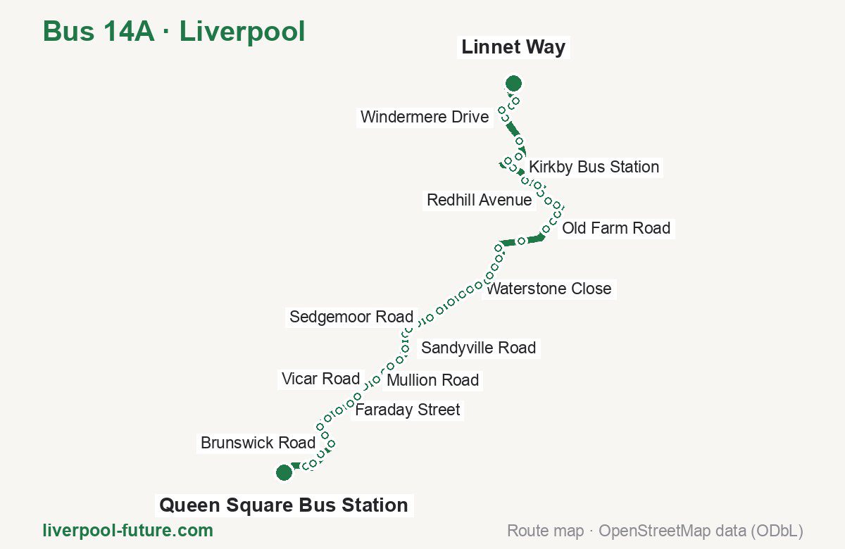
Bus 14A in Liverpool links Queen Square Bus Station and Linnet Way. The route is 18.0 km long with 49 stops, and the official schedule from Merseytravel puts the full trip at about 62 minutes. On a weekday it runs 25 trips in one direction, and 18 on a weekend day.
Route at a glance
| Mode | Bus |
|---|---|
| Route number | 14A |
| City | Liverpool |
| Operator | Merseytravel |
| Start → end | Queen Square Bus Station → Linnet Way |
| End → start | Linnet Way → Queen Square Bus Station |
| Route length | 18.0 km / 20.2 km in the opposite direction |
| Number of stops | 49 / 54 in the opposite direction |
| Travel time | about 62 minutes |
| Trips per day | 25 on weekdays, 18 on weekends one way |
| Frequency | peak 27–39 · midday 36 · weekend 28–31 |
| First / last trip from «Queen Square Bus Station» | 07:26 / 22:37 |
| First / last trip from «Linnet Way» | 06:42 / 22:30 |
| Fare | 2.00 £ (fare in effect since September 2022) |
| Updated | August 22, 2026 |
Route of Bus 14A
Outbound: Queen Square Bus Station → Linnet Way
This direction has 49 stops and runs 18.0 km. The route passes Monument Place, Vicar Road, Oakgate Close, Shaldon Close. Below is the full list with the distance from the first stop.
| No. | Stop | From start | Note |
|---|---|---|---|
| 1 | Queen Square Bus Station | 0.0 km | Terminus |
| 2 | Monument Place | 0.7 km | |
| 3 | Royal Liverpool University Hospital | 1.1 km | |
| 4 | Shaw Street | 1.4 km | |
| 5 | Brunswick Road | 1.9 km | |
| 6 | Plumpton Street | 2.2 km | |
| 7 | Lloyd Close | 2.5 km | |
| 8 | Lance Close | 2.8 km | |
| 9 | Faraday Street | 3.2 km | |
| 10 | Grasmere Street | 3.5 km | |
| 11 | St Andrew Road | 3.8 km | |
| 12 | Abbey Road | 4.1 km | |
| 13 | Vicar Road | 4.5 km | |
| 14 | Pinehurst Avenue | 4.8 km | |
| 15 | Richard Kelly Drive | 5.0 km | |
| 16 | Cherry Lane | 5.4 km | |
| 17 | Sandyville Road | 5.7 km | |
| 18 | Broad Lane | 6.1 km | |
| 19 | Henry A Cole Library | 6.3 km | |
| 20 | Parthenon Drive | 6.6 km | |
| 21 | Sedgemoor Road | 7.0 km | |
| 22 | Scargreen Avenue | 7.3 km | |
| 23 | Cottesbrook Road | 7.7 km | |
| 24 | Oakgate Close | 8.0 km | |
| 25 | Waterstone Close | 8.3 km | |
| 26 | Standard Road | 8.6 km | |
| 27 | Unicorn Road | 8.9 km | |
| 28 | Cubert Road | 9.0 km | |
| 29 | Mullion Road | 9.3 km | |
| 30 | Newlyn Road | 9.6 km | |
| 31 | Petherick Road | 9.9 km | |
| 32 | M57 | 10.7 km | |
| 33 | Old Farm Road | 11.5 km | |
| 34 | Bewley Drive | 11.8 km | |
| 35 | Shaldon Close | 12.0 km | |
| 36 | Shaldon Road | 12.4 km | |
| 37 | Redhill Avenue | 12.6 km | |
| 38 | Lydbury Crescent | 13.0 km | |
| 39 | Leeside Avenue | 13.3 km | |
| 40 | Wellfield Avenue | 13.7 km | |
| 41 | Kirkby Bus Station | 14.4 km | |
| 42 | Old Hall Lane | 14.9 km | |
| 43 | Millbrook Drive | 15.2 km | |
| 44 | Melling Drive | 15.8 km | |
| 45 | Windermere Drive | 16.5 km | |
| 46 | Bank Lane | 16.8 km | |
| 47 | Ebony Way | 17.1 km | |
| 48 | Saxon Way | 17.2 km | |
| 49 | Linnet Way | 18.0 km | Terminus |
Inbound: Linnet Way → Queen Square Bus Station
This direction has 54 stops and runs 20.2 km. The route passes Swallow Close, Rowlings Way, Worrow Road, Belmont Road. Below is the full list with the distance from the first stop.
| No. | Stop | From start | Note |
|---|---|---|---|
| 1 | Linnet Way | 0.0 km | Terminus |
| 2 | Swallow Close | 0.3 km | |
| 3 | Hobart Drive | 0.5 km | |
| 4 | Epsom Grove | 1.3 km | |
| 5 | Freckleton Drive | 1.9 km | |
| 6 | Hollinghurst Road | 2.3 km | |
| 7 | Headbolt Lane Interchange | 2.8 km | |
| 8 | St Kevins Drive | 3.4 km | |
| 9 | County Road | 3.7 km | |
| 10 | County Road | 4.0 km | |
| 11 | Old Hall Lane | 4.3 km | |
| 12 | Kirkby Bus Station | 4.7 km | |
| 13 | Cherryfield Drive | 5.3 km | |
| 14 | Mainside Road | 5.7 km | |
| 15 | Rowlings Way | 6.0 km | |
| 16 | Broad Lane | 6.2 km | |
| 17 | Moorgate Road | 6.6 km | |
| 18 | Britonside Avenue | 6.7 km | |
| 19 | Sedburn Road | 7.0 km | |
| 20 | Old Farm Road | 7.4 km | |
| 21 | Moorgate Road | 7.9 km | |
| 22 | Willow Way | 9.0 km | |
| 23 | Tintagel Road | 9.5 km | |
| 24 | Moss Way | 9.7 km | |
| 25 | Cubert Road | 9.9 km | |
| 26 | Sceptre Road | 10.2 km | |
| 27 | Stonebridge Lane | 10.5 km | |
| 28 | Worrow Road | 10.9 km | |
| 29 | Carsington Road | 11.3 km | |
| 30 | Stalisfield Avenue | 11.7 km | |
| 31 | Lewisham Road | 12.1 km | |
| 32 | Lorenzo Drive | 12.4 km | |
| 33 | Broadway | 12.6 km | |
| 34 | Utting Avenue East | 12.8 km | |
| 35 | Queens Drive | 13.3 km | |
| 36 | Maiden Lane | 13.7 km | |
| 37 | Pinehurst Avenue | 14.1 km | |
| 38 | Vicar Road | 14.4 km | |
| 39 | Lower Breck Road | 14.9 km | |
| 40 | Sedley Street | 15.1 km | |
| 41 | Belmont Road | 15.4 km | |
| 42 | Queens Road | 15.8 km | |
| 43 | Dobson Street | 16.2 km | |
| 44 | Everton Road | 16.4 km | |
| 45 | Plumpton Street | 16.8 km | |
| 46 | West Derby Road | 17.0 km | |
| 47 | Royal Liverpool University Hospital | 17.6 km | |
| 48 | Royal Liverpool University Hospital | 17.8 km | |
| 49 | Greek Street | 18.4 km | |
| 50 | Lime Street Station | 18.9 km | |
| 51 | Queen Square Bus Station | 19.2 km | |
| 52 | Cumberland Street | 19.7 km | |
| 53 | North John Street | 19.9 km | |
| 54 | Castle Street | 20.2 km | Terminus |
Schedule and frequency
According to the official schedule from Merseytravel, the route runs 25 trips in one direction on a weekday, and 18 on a weekend day.
| Direction | Weekdays | Weekends and holidays |
|---|---|---|
| From «Queen Square Bus Station» | 07:26 — 22:37 | 09:11 — 17:40 |
| From «Linnet Way» | 06:42 — 22:30 | 08:51 — 17:46 |
Frequency calculated from the departure table: in the morning peak buses run every 27–39 minutes, most often every 36; midday every 36 minutes; in the afternoon peak every 12–55; on weekends every 28–31 minutes.
Fare and payment
A single ride costs 2.00 £ — fare in effect since September 2022. The same fare applies to buses in Merseyside.
No adult single bus journey costs more than £2.00 — this cap set by the Liverpool City Region applies to every operator in Merseyside and Halton. Each boarding counts as a separate journey: there is no transfer. A Solo day ticket is £5.90.
Frequently asked questions
How much does a ride on bus 14A cost?
2.00 £ for a single ride — fare in effect since September 2022.
When do the first and last trips run?
From Queen Square Bus Station the first is at 07:26 and the last at 22:37. From Linnet Way they are 06:42 and 22:30.
How long does the trip from Queen Square Bus Station to Linnet Way take?
About 62 minutes end to end — the median of full trips in the official schedule.
How many stops does the route have?
49 outbound and 54 inbound according to the official GTFS feed. The two lists do not match exactly.
Does bus 14A run on weekends?
Yes. On weekends and holidays there are 18 trips in one direction, running from Queen Square Bus Station between 09:11 and 17:40.
Every route number with its termini, operating hours and travel time is collected in the Liverpool buses overview.
Data current as of August 22, 2026. Schedule and termini — Merseytravel. Fares — Merseytravel. Stop list, schedule and route geometry come from the official GTFS feed (Bus Open Data Service (BODS)).