

Bus 217A in Liverpool links Bootle Bus Station and Halewood Shopping Centre. The route is 40.0 km long with 105 stops, and the official schedule from Merseytravel puts the full trip at about 61 minutes. On a weekday it runs 4 trips in one direction, and 9 on a weekend day.
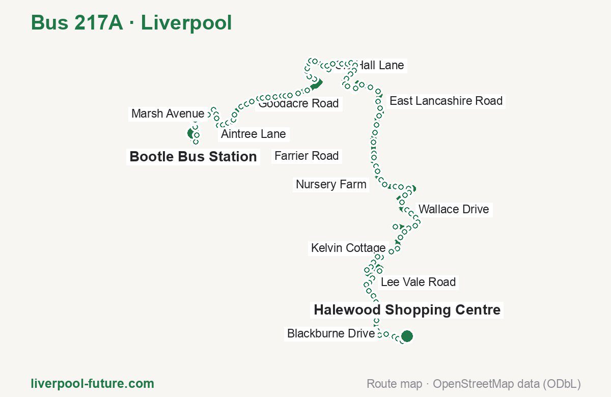
Route at a glance
| Mode | Bus |
|---|---|
| Route number | 217A |
| City | Liverpool |
| Operator | Merseytravel |
| Start → end | Bootle Bus Station → Halewood Shopping Centre |
| End → start | Halewood Shopping Centre → Bootle Bus Station |
| Route length | 39.9 km / 26.9 km in the opposite direction |
| Number of stops | 105 / 71 in the opposite direction |
| Travel time | about 61 minutes |
| Trips per day | 4 on weekdays, 9 on weekends one way |
| Frequency | weekend 110 |
| First / last trip from «Bootle Bus Station» | 18:42 / 21:40 |
| First / last trip from «Halewood Shopping Centre» | 19:14 / 23:44 |
| Fare | 2.00 £ (fare in effect since September 2022) |
| Updated | August 22, 2026 |
Route of Bus 217A
Outbound: Bootle Bus Station → Halewood Shopping Centre
This direction has 105 stops and runs 40.0 km. The route passes St Albans Road, Haven Road, Lees Road, Quarry Gardens. Below is the full list with the distance from the first stop.
| No. | Stop | From start | Note |
|---|---|---|---|
| 1 | Bootle Bus Station | 0.0 km | Terminus |
| 2 | St Albans Road | 0.5 km | |
| 3 | Bootle Strand Interchange | 1.0 km | |
| 4 | Hornby Road | 1.4 km | |
| 5 | Knowsley Road | 1.7 km | |
| 6 | Knowsley Road | 1.8 km | |
| 7 | Hawthorne Road | 2.2 km | |
| 8 | Fernhill Road | 2.5 km | |
| 9 | Watts Lane | 2.9 km | |
| 10 | Marsh Avenue | 3.4 km | |
| 11 | Keir Hardie Avenue | 3.6 km | |
| 12 | Connolly Avenue | 4.0 km | |
| 13 | Hornby Close | 4.2 km | |
| 14 | Rice Lane Interchange | 4.5 km | |
| 15 | Rice Lane Interchange | 4.8 km | |
| 16 | Rice Lane Interchange | 4.9 km | |
| 17 | Orrell Park Interchange | 5.2 km | |
| 18 | Warbreck Moor | 5.7 km | |
| 19 | Goodacre Road | 6.0 km | |
| 20 | Greenwich Road | 6.3 km | |
| 21 | Seeds Lane | 6.7 km | |
| 22 | Barlows Lane | 6.9 km | |
| 23 | Fazakerley Interchange | 7.2 km | |
| 24 | Longmoor Close | 7.6 km | |
| 25 | Sherwoods Lane | 7.9 km | |
| 26 | New Hall Cottages | 8.1 km | |
| 27 | Haven Road | 8.3 km | |
| 28 | Aintree Lane | 8.7 km | |
| 29 | Ingoe Lane | 9.2 km | |
| 30 | James Holt Avenue | 10.4 km | |
| 31 | Ingoe Close | 10.7 km | |
| 32 | Houlston Road | 11.0 km | |
| 33 | Richard Hesketh Drive | 11.1 km | |
| 34 | Lingtree Road | 11.4 km | |
| 35 | Kirkby Interchange | 11.6 km | |
| 36 | Kirkby Interchange | 11.8 km | |
| 37 | Old Hall Lane | 12.3 km | |
| 38 | Kirkby Bus Station | 12.7 km | |
| 39 | Old Hall Lane | 13.3 km | |
| 40 | Millbrook Drive | 13.6 km | |
| 41 | Briery Hey Avenue | 14.1 km | |
| 42 | Bigdale Drive | 14.3 km | |
| 43 | Harleston Road | 14.6 km | |
| 44 | Mintor Road | 14.9 km | |
| 45 | Simonswood Walk | 15.2 km | |
| 46 | Farrier Road | 15.5 km | |
| 47 | Edgefold Road | 15.8 km | |
| 48 | Rowlings Way | 16.1 km | |
| 49 | Broad Lane | 16.3 km | |
| 50 | Moorgate Road | 16.7 km | |
| 51 | Lindby Close | 16.9 km | |
| 52 | Lees Road | 17.4 km | |
| 53 | Kirkby Admin | 17.9 km | |
| 54 | Spinney Road | 18.3 km | |
| 55 | East Lancashire Road | 18.9 km | |
| 56 | East Lancashire Road | 19.3 km | |
| 57 | Ormskirk Road | 19.7 km | |
| 58 | Tithebarn Road | 20.2 km | |
| 59 | Shop Road | 20.6 km | |
| 60 | Sugar Lane | 21.1 km | |
| 61 | Shannons Lane | 21.7 km | |
| 62 | Croxteth Lane | 21.9 km | |
| 63 | Knowlsey Road Farm | 22.3 km | |
| 64 | Nursery Farm | 22.6 km | |
| 65 | Stockbridge Lane | 23.1 km | |
| 66 | Thornton Way | 23.4 km | |
| 67 | Astley Road | 24.0 km | |
| 68 | Forest Grove | 24.3 km | |
| 69 | Liverpool Road | 24.6 km | |
| 70 | Blenheim Drive | 25.3 km | |
| 71 | Lyme Cross Road | 25.5 km | |
| 72 | Wellcroft Road | 26.1 km | |
| 73 | Wallace Drive | 26.8 km | |
| 74 | Hurst Park Drive | 27.0 km | |
| 75 | Hardie Road | 27.4 km | |
| 76 | The Crescent | 27.6 km | |
| 77 | Quarry Gardens | 27.9 km | |
| 78 | De Silva Street | 28.2 km | |
| 79 | Huyton Bus Station | 29.1 km | |
| 80 | St Agnes Road | 29.8 km | |
| 81 | Manor Farm Road | 30.1 km | |
| 82 | Kelvin Cottage | 30.8 km | |
| 83 | Holt Lane | 31.1 km | |
| 84 | Silverbrook Road | 31.8 km | |
| 85 | Southbrook Road | 32.0 km | |
| 86 | St Cyrils Close | 32.4 km | |
| 87 | Runton Road | 33.2 km | |
| 88 | Belle Vale Interchange | 33.6 km | |
| 89 | Belle Vale Bus Station | 34.0 km | |
| 90 | Jones Farm Road | 34.7 km | |
| 91 | Lee Vale Road | 35.0 km | |
| 92 | Halewood Road | 35.2 km | |
| 93 | The Nook | 35.6 km | |
| 94 | Roxborough Walk | 35.9 km | |
| 95 | Halewood Way | 36.3 km | |
| 96 | Arncliffe Road | 36.9 km | |
| 97 | Camberley Drive | 37.2 km | |
| 98 | Roskell Road | 37.8 km | |
| 99 | Mackets Lane | 38.1 km | |
| 100 | Blackburne Drive | 38.4 km | |
| 101 | Wood Road | 38.9 km | |
| 102 | Mansell Drive | 39.1 km | |
| 103 | Higher Road | 39.4 km | |
| 104 | Beechwood Avenue | 39.6 km | |
| 105 | Halewood Shopping Centre | 39.9 km | Terminus |
Inbound: Halewood Shopping Centre → Bootle Bus Station
This direction has 71 stops and runs 26.9 km. The route passes Roseheath Drive, Runton Road, Wellcroft Road, East Lancashire Road. Below is the full list with the distance from the first stop.
| No. | Stop | From start | Note |
|---|---|---|---|
| 1 | Halewood Shopping Centre | 0.1 km | Terminus |
| 2 | Roseheath Drive | 0.4 km | |
| 3 | Leathers Lane | 0.7 km | |
| 4 | Mansell Drive | 0.9 km | |
| 5 | Torrington Drive | 1.2 km | |
| 6 | Blackburne Drive | 1.4 km | |
| 7 | Portway | 1.8 km | |
| 8 | Roskell Road | 2.2 km | |
| 9 | Camberley Drive | 2.8 km | |
| 10 | Linkside Road | 3.1 km | |
| 11 | Halewood Drive | 3.6 km | |
| 12 | Out Lane | 4.1 km | |
| 13 | Hollytree Road | 4.5 km | |
| 14 | Grange Lane | 4.8 km | |
| 15 | Belle Vue Road | 5.0 km | |
| 16 | Jones Farm Road | 5.3 km | |
| 17 | Belle Vale Bus Station | 5.9 km | |
| 18 | Belle Vale Interchange | 6.3 km | |
| 19 | Runton Road | 6.7 km | |
| 20 | Abbeyvale Drive | 7.2 km | |
| 21 | St Cyrils Close | 7.5 km | |
| 22 | Farmview Close | 7.9 km | |
| 23 | Silverbrook Road | 8.1 km | |
| 24 | Holt Lane | 8.8 km | |
| 25 | The Chase | 9.4 km | |
| 26 | Manor Farm Road | 9.8 km | |
| 27 | St Annes Road | 10.0 km | |
| 28 | St Agnes Road | 10.3 km | |
| 29 | Huyton Bus Station | 10.9 km | |
| 30 | School Lane | 11.9 km | |
| 31 | Poplar Way | 12.2 km | |
| 32 | Longview Drive | 12.4 km | |
| 33 | Hardie Road | 12.7 km | |
| 34 | Hurst Park Drive | 12.9 km | |
| 35 | Edenfield Crescent | 13.3 km | |
| 36 | Wellcroft Road | 14.0 km | |
| 37 | Hillside Road | 14.3 km | |
| 38 | Lyme Cross Road | 14.7 km | |
| 39 | Radway Road | 15.4 km | |
| 40 | Forest Grove | 15.7 km | |
| 41 | Primrose Drive | 16.0 km | |
| 42 | Newark Close | 16.3 km | |
| 43 | Park Way | 16.7 km | |
| 44 | Nursery Farm | 17.3 km | |
| 45 | Knowlsey Road Farm | 17.6 km | |
| 46 | Croxteth Lane | 17.9 km | |
| 47 | Shannons Lane | 18.3 km | |
| 48 | Home Farm Lane | 18.6 km | |
| 49 | Pinfold Lane | 19.0 km | |
| 50 | Shop Road | 19.4 km | |
| 51 | School Lane | 19.9 km | |
| 52 | Kitling Road | 20.3 km | |
| 53 | East Lancashire Road | 20.7 km | |
| 54 | East Lancashire Road | 21.0 km | |
| 55 | Hornhouse Lane | 21.3 km | |
| 56 | Coopers Lane | 21.6 km | |
| 57 | Admin Road | 22.1 km | |
| 58 | Hornhouse Lane | 22.5 km | |
| 59 | Moorgate Lane | 22.9 km | |
| 60 | Shaldon Road | 23.1 km | |
| 61 | Redhill Avenue | 23.4 km | |
| 62 | Lydbury Crescent | 23.8 km | |
| 63 | Edgefold Road | 24.1 km | |
| 64 | Madryn Avenue | 24.4 km | |
| 65 | Simonswood Walk | 24.6 km | |
| 66 | Colwall Walk | 24.9 km | |
| 67 | Cygnet Court | 25.2 km | |
| 68 | Minstead Avenue | 25.4 km | |
| 69 | Briery Hey Avenue | 25.8 km | |
| 70 | County Road | 26.2 km | |
| 71 | Kirkby Bus Station | 26.9 km | Terminus |
Schedule and frequency
According to the official schedule from Merseytravel, the route runs 4 trips in one direction on a weekday, and 9 on a weekend day.
| Direction | Weekdays | Weekends and holidays |
|---|---|---|
| From «Bootle Bus Station» | 18:42 — 21:40 | 06:06 — 21:40 |
| From «Halewood Shopping Centre» | 19:14 — 23:44 | 07:41 — 23:44 |
Frequency calculated from the departure table: in the afternoon peak every 53; on weekends every 110 minutes.
Fare and payment
A single ride costs 2.00 £ — fare in effect since September 2022. The same fare applies to buses in Merseyside.
No adult single bus journey costs more than £2.00 — this cap set by the Liverpool City Region applies to every operator in Merseyside and Halton. Each boarding counts as a separate journey: there is no transfer. A Solo day ticket is £5.90.
Frequently asked questions
How much does a ride on bus 217A cost?
2.00 £ for a single ride — fare in effect since September 2022.
When do the first and last trips run?
From Bootle Bus Station the first is at 18:42 and the last at 21:40. From Halewood Shopping Centre they are 19:14 and 23:44.
How long does the trip from Bootle Bus Station to Halewood Shopping Centre take?
About 61 minutes end to end — the median of full trips in the official schedule.
How many stops does the route have?
105 outbound and 71 inbound according to the official GTFS feed. The two lists do not match exactly.
Does bus 217A run on weekends?
Yes. On weekends and holidays there are 9 trips in one direction, running from Bootle Bus Station between 06:06 and 21:40.
Every route number with its termini, operating hours and travel time is collected in the Liverpool buses overview.
Data current as of August 22, 2026. Schedule and termini — Merseytravel. Fares — Merseytravel. Stop list, schedule and route geometry come from the official GTFS feed (Bus Open Data Service (BODS)).