

Bus 102 in Liverpool links Aintree University Hospital and Stockbridge Lane. The route is 23.0 km long with 65 stops, and the official schedule from Merseytravel puts the full trip at about 54 minutes. On a weekday it runs 17 trips in one direction.
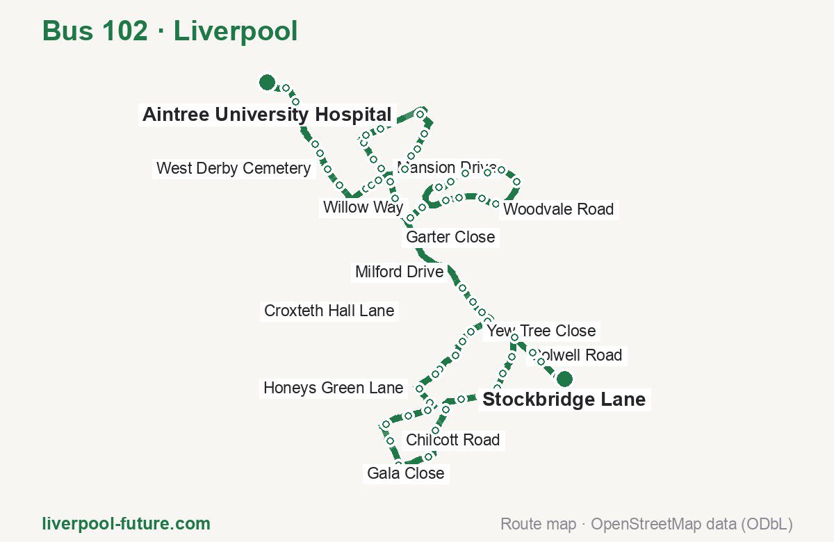
Route at a glance
| Mode | Bus |
|---|---|
| Route number | 102 |
| City | Liverpool |
| Operator | Merseytravel |
| Start → end | Aintree University Hospital → Stockbridge Lane |
| End → start | Stockbridge Lane → Aintree University Hospital |
| Route length | 23.0 km / 22.3 km in the opposite direction |
| Number of stops | 65 / 63 in the opposite direction |
| Travel time | about 54 minutes |
| Trips per day | 17 on weekdays one way |
| Frequency | peak 60 · midday 60 |
| First / last trip from «Aintree University Hospital» | 07:05 / 23:05 |
| First / last trip from «Stockbridge Lane» | 07:05 / 23:35 |
| Fare | 2.00 £ (fare in effect since September 2022) |
| Updated | August 22, 2026 |
Route of Bus 102
Outbound: Aintree University Hospital → Stockbridge Lane
This direction has 65 stops and runs 23.0 km. The route passes Aintree University Hospital, Tintagel Road, Measham Way, Meadowcroft Park. Below is the full list with the distance from the first stop.
| No. | Stop | From start | Note |
|---|---|---|---|
| 1 | Aintree University Hospital | 0.0 km | Terminus |
| 2 | Aintree University Hospital | 0.4 km | |
| 3 | Aintree University Hospital | 0.7 km | |
| 4 | Police Station | 1.5 km | |
| 5 | Long Lane | 1.7 km | |
| 6 | West Derby Cemetery | 2.0 km | |
| 7 | West Derby Cemetery | 2.3 km | |
| 8 | Oakgate Close | 2.9 km | |
| 9 | Worrow Road | 3.0 km | |
| 10 | Waterstone Close | 3.2 km | |
| 11 | Mansion Drive | 3.5 km | |
| 12 | Stonedale Crescent | 3.7 km | |
| 13 | Stonedale Cresent | 4.0 km | |
| 14 | Stonebridge Lane | 4.2 km | |
| 15 | Stonebridge Lane | 4.4 km | |
| 16 | Willow Way | 5.4 km | |
| 17 | Tintagel Road | 5.8 km | |
| 18 | Moss Way | 6.1 km | |
| 19 | Cubert Road | 6.3 km | |
| 20 | Sceptre Road | 6.5 km | |
| 21 | Garter Close | 7.0 km | |
| 22 | Mace Road | 7.3 km | |
| 23 | Croxteth Hall Lane | 7.8 km | |
| 24 | Abbeyfield Drive | 8.0 km | |
| 25 | Grayling Drive | 8.5 km | |
| 26 | Milford Drive | 8.7 km | |
| 27 | Langley Close | 9.1 km | |
| 28 | Mullwood Close | 9.4 km | |
| 29 | Verwood Drive | 9.9 km | |
| 30 | Nightingale Road | 10.3 km | |
| 31 | Woodvale Road | 10.6 km | |
| 32 | Measham Way | 10.9 km | |
| 33 | Veronica Close | 11.2 km | |
| 34 | Crucian Way | 11.4 km | |
| 35 | Fir Tree Drive South | 11.9 km | |
| 36 | Croxteth Hall Lane | 12.2 km | |
| 37 | Deysbrook Lane | 13.8 km | |
| 38 | Colden Close | 14.1 km | |
| 39 | no. 265 | 14.3 km | |
| 40 | Leamoore Close | 14.6 km | |
| 41 | Yew Tree Close | 14.9 km | |
| 42 | St Andrews Avenue | 15.2 km | |
| 43 | Grange Avenue | 15.4 km | |
| 44 | Martlett Road | 15.8 km | |
| 45 | Honey’s Green Close | 15.9 km | |
| 46 | Honeys Green Lane | 16.3 km | |
| 47 | Meadowcroft Park | 16.6 km | |
| 48 | Thomas Lane | 16.8 km | |
| 49 | Rudyard Road | 17.1 km | |
| 50 | Queens Drive | 17.5 km | |
| 51 | Chilcott Road | 17.9 km | |
| 52 | Broadgreen Hospital | 18.3 km | |
| 53 | Broadgreen Hospital | 18.9 km | |
| 54 | Thingwall Lane | 19.4 km | |
| 55 | East Prescot Road | 19.8 km | |
| 56 | Gala Close | 20.1 km | |
| 57 | Ackers Hall Avenue | 20.5 km | |
| 58 | East Prescot Road | 20.8 km | |
| 59 | Finch Way | 21.1 km | |
| 60 | Ruscombe Road | 21.4 km | |
| 61 | Colwell Road | 21.8 km | |
| 62 | Saxby Road | 22.2 km | |
| 63 | Lordens Road | 22.4 km | |
| 64 | Stockbridge Lane | 22.7 km | |
| 65 | Stockbridge Lane | 23.0 km | Terminus |
Inbound: Stockbridge Lane → Aintree University Hospital
This direction has 63 stops and runs 22.3 km. The route passes Liverpool Road, East Prescot Road, Mullwood Close, Petherick Road. Below is the full list with the distance from the first stop.
| No. | Stop | From start | Note |
|---|---|---|---|
| 1 | Stockbridge Lane | 0.0 km | Terminus |
| 2 | Liverpool Road | 0.2 km | |
| 3 | Lordens Road | 0.6 km | |
| 4 | Burtree Road | 0.9 km | |
| 5 | Princess Drive | 1.3 km | |
| 6 | Fincham Road | 1.6 km | |
| 7 | Finch Way | 1.9 km | |
| 8 | Dovecot Avenue | 2.3 km | |
| 9 | Churchdown Grove | 2.6 km | |
| 10 | Pilch Bank Road | 2.9 km | |
| 11 | Pilch Lane | 3.1 km | |
| 12 | Brookside Avenue | 3.4 km | |
| 13 | Broadgreen Hospital | 3.9 km | |
| 14 | Broadgreen Hospital | 4.2 km | |
| 15 | Thingwall Lane | 4.7 km | |
| 16 | East Prescot Road | 5.0 km | |
| 17 | East Prescot Road | 5.5 km | |
| 18 | Honeys Green Lane | 5.7 km | |
| 19 | Blackmoor Drive | 6.1 km | |
| 20 | Hilda Road | 6.5 km | |
| 21 | Westerton Road | 6.7 km | |
| 22 | St Andrew’s Avenue | 7.0 km | |
| 23 | Aspes Road | 7.4 km | |
| 24 | no. 62 | 7.7 km | |
| 25 | Aspes Road | 7.9 km | |
| 26 | Deysbrook Lane | 8.2 km | |
| 27 | Croxteth Hall Lane | 9.8 km | |
| 28 | Abbeyfield Drive | 10.1 km | |
| 29 | Grayling Drive | 10.6 km | |
| 30 | Milford Drive | 10.8 km | |
| 31 | Langley Close | 11.2 km | |
| 32 | Mullwood Close | 11.4 km | |
| 33 | Verwood Drive | 12.0 km | |
| 34 | Nightingale Road | 12.3 km | |
| 35 | Woodvale Road | 12.6 km | |
| 36 | Measham Way | 13.0 km | |
| 37 | Veronica Close | 13.3 km | |
| 38 | Crucian Way | 13.5 km | |
| 39 | Fir Tree Drive South | 14.0 km | |
| 40 | Croxteth Hall Lane | 14.3 km | |
| 41 | Mace Road | 14.7 km | |
| 42 | Standard Road | 15.3 km | |
| 43 | Unicorn Road | 15.6 km | |
| 44 | Cubert Road | 15.7 km | |
| 45 | Mullion Road | 16.0 km | |
| 46 | Newlyn Road | 16.3 km | |
| 47 | Petherick Road | 16.6 km | |
| 48 | Back Gillmoss Lane | 17.1 km | |
| 49 | Stonebridge Lane | 17.5 km | |
| 50 | East Lancashire Road | 17.9 km | |
| 51 | Stonedale Crescent | 18.1 km | |
| 52 | Mansion Drive | 18.4 km | |
| 53 | Stonebridge Lane | 18.5 km | |
| 54 | Worrow Road | 18.9 km | |
| 55 | Utting Avenue East | 19.3 km | |
| 56 | West Derby Cemetery | 19.5 km | |
| 57 | East Lancashire Road | 19.9 km | |
| 58 | Ternhall Road | 20.1 km | |
| 59 | Police Station | 20.4 km | |
| 60 | Aintree University Hospital | 21.3 km | |
| 61 | Aintree University Hospital | 21.5 km | |
| 62 | Fazakerley Interchange | 21.7 km | |
| 63 | Aintree University Hospital | 22.3 km | Terminus |
Schedule and frequency
According to the official schedule from Merseytravel, the route runs 17 trips in one direction on a weekday.
| Direction | Weekdays | Weekends and holidays |
|---|---|---|
| From «Aintree University Hospital» | 07:05 — 23:05 | — — — |
| From «Stockbridge Lane» | 07:05 — 23:35 | 07:35 — 23:35 |
Frequency calculated from the departure table: in the morning peak buses run every 60 minutes; midday every 60 minutes; in the afternoon peak every 60.
Fare and payment
A single ride costs 2.00 £ — fare in effect since September 2022. The same fare applies to buses in Merseyside.
No adult single bus journey costs more than £2.00 — this cap set by the Liverpool City Region applies to every operator in Merseyside and Halton. Each boarding counts as a separate journey: there is no transfer. A Solo day ticket is £5.90.
Frequently asked questions
How much does a ride on bus 102 cost?
2.00 £ for a single ride — fare in effect since September 2022.
When do the first and last trips run?
From Aintree University Hospital the first is at 07:05 and the last at 23:05. From Stockbridge Lane they are 07:05 and 23:35.
How long does the trip from Aintree University Hospital to Stockbridge Lane take?
About 54 minutes end to end — the median of full trips in the official schedule.
How many stops does the route have?
65 outbound and 63 inbound according to the official GTFS feed. The two lists do not match exactly.
Does bus 102 run on weekends?
Yes, the route runs every day, with a separate weekend schedule.
Every route number with its termini, operating hours and travel time is collected in the Liverpool buses overview.
Data current as of August 22, 2026. Schedule and termini — Merseytravel. Fares — Merseytravel. Stop list, schedule and route geometry come from the official GTFS feed (Bus Open Data Service (BODS)).